The summer season is officially here and it’s bloomin’ trolleys!
Each year – and thanks to Laguna taking the lead years ago with its enormously successful trolley program – it seems that one more city jumps into the trolley trend.
28 Miles of Trolley Trolling
Now, you can virtually begin your trolley travels at the farthest north edge of Laguna Beach and, by working your way through connected trolley systems, mosey all the way to and through Dana Point, the Dana Point Harbor, Capo Beach and – now – San Juan Capistrano.
Diane’s added note on Sat, 6/24/2017: Yep, kudos to San Clemente’s City Council for implementing San Clemente free trolleys, too. It’s their inaugural year, so do everything you can to support these newbies to the pack. I’ve added their information below, along with their map route for central San Clemente. HOPEFULLY, the City of Dana Point and the City of San Clemente will find a way to connect their trolleys along Coast Highway/North El Camino Real SOON! The San Clemente trolley extends down to its Metrolink Station there, while the Dana Point trolley does its final stop and turn, just about a half mile from there at Beach Road. Call your respective cities, and kindly make the suggestion!
Yesterday, on my Facebook page, one of my readers complained about summer’s parking tickets in Laguna Beach. This just makes me shake my head in woe. With miles and miles of trolley routes available to everyone … and with Uber dropping you at even the farthest-flung points to catch your trolley and connect into Laguna, I would think that parking tickets could become virtually obsolete.
Get Out and Explore!
Aside from alleviating the parking hassle in each of these summery towns, you’ve just been given a free passport to explore our glorious coastal wedge, from the now-hopping SJC train station restaurants to Doheny Beach festivals, the Ocean Institute’s tall ship excursions, Dana Point and Laguna Beach free concerts in designated parks, Dana Point’s gorgeous Nature Center and phenomenal resorts and, of course, the gems of Laguna Beach and her festival centers in the Canyon.
Summer 2017’s Four Main Trolley Systems
#1
Laguna Beach Trolleys – North to South
Schedule Through Late June:
Fridays: 4 p.m. – 11 p.m.
Saturday: 11 a.m. – 11 p.m.
Sundays: 11 a.m. – 8 p.m.
Schedule July & August
Daily: 9:30 a.m. – 11:30 p.m.
4th of July: The trolleys stop at 7:00 p.m.
Frequency: Every 20 minutes, depending on traffic conditions
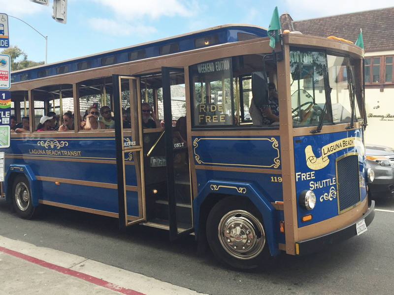
Recognize the free Laguna Beach North/South Trolley:

Basic Route: Along Coast Highway from Cajon Street in North Laguna to The Ritz-Carlton in Dana Point.
This year, Laguna is also offering a “Limited Stop” Coastal Route trolley that only stops at 8 primary locations, from Main Beach to primary resorts and, then, Crown Valley and The Ritz-Carlton. (So, if you see a trolley whiz past you, remember that we now have “express trolleys” in town.)
Trolley Stops: More than 40 hop-on stops available. Our great visitor’s bureau, Visit Laguna Beach, has rolled out a super-slick and revised ” Trolley Tracker” so you can see where your trolley is in real time.
Map: Download the Laguna Beach Trolley Map 2017 here.
#2
Laguna Beach Trolleys – Laguna Canyon/Downtown
Schedule Through Late June:
Fridays: 4 p.m. – 11 p.m.
Saturday: 11 a.m. – 11 p.m.
Sundays: 11 a.m. – 8 p.m.
Schedule July & August
Daily: 9:30 a.m. – 11:30 p.m.
4th of July: The trolleys stop at 7:00 p.m.
Frequency: Every 20 minutes, depending on traffic conditions
Recognize the free Laguna Beach Canyon/Festival/Downtown Trolley:

Basic Route: Stretching all the way to El Toro Road’s “Parking Lot 10,” the Canyon Trolley stops at primary festival points and noodles into primary downtown streets
Trolley Stops: 7 Canyon stops, 8 downtown hops. As above, check out the Laguna Beach Trolley Tracker to see where your trolley is in real time.
Map: This map is part of the larger Laguna Beach Trolley map, above, provided by The City of Laguna Beach.
#3
Dana Point Trolleys
Schedule: June 9 through Labor Day (Sept. 4)
Mon – Thurs + Sundays: Noon – 9:00 p.m.
Friday: Noon – 10:00 p.m.
Saturday: 10:00 a.m. – 10:00 p.m.
Holidays: 10 a.m. – 8:30 p.m.
Frequency: Every 15 minutes, depending on traffic conditions
Recognize the free Dana Point Trolley (photo credit: Dana Point Times):

Basic Route: Connects to Laguna Beach trolleys at The Ritz-Carlton and Salt Creek Beach.
One trolley branch covers Niguel Road to Camino Del Avion.
The primary route runs along Pacific Coast Highway and Del Prado (Lantern District), down to the Dana Point Harbor, connecting to the Harbor shuttles, and all the way to Beach Road in Capo Beach. It also wanders along Doheny Park Road, parallel to the 5, and meandering into San Juan Capistrano to connect with their trolley system.
Trolley Stops: Expanded this year to 26 hop-on stops. Real time Dana Point trolley tracker here.
Map: Download Dana Point Trolley Map here
#4
Dana Point Harbor Shuttles
Schedule: June 9 through Labor Day (Sept. 4)
Mon – Thurs: 10:00 a.m. – 9:00 p.m.
Fri, Sat, Sun: Noon – 9:00 p.m.
Frequency: Every 15 minutes, depending on traffic conditions
Recognize the free Dana Point Harbor Shuttles (photo credit Dana Point Times):

DP Harbor Basic Route: Connects to Dana Point trolleys at Golden Lantern and Dana Point Harbor Drive.
These trolleys run all exterior and interior loops of the Harbor
Trolley Stops: 5 hop-on stops. Real time Dana Point trolley tracker here.
Map: The Harbor Shuttle map is part of the Dana Point Trolley map, above.
#5
San Juan Capistrano Trolleys
Schedule: June 9 through Labor Day (Sept. 4)
Fri: 5 p.m. – 10:00 p.m.
Sat: 11 a.m. – 10:00 p.m.
Sun: 11 a.m. – 5:00 p.m.
Frequency: Every 20 minutes, depending on traffic conditions
Recognize the free San Juan Capistrano trolleys (photo credit OC Register):

SJC Basic Route: Connects to Dana Point trolleys at Stonehill and Del Obispo Streets.
These trolleys run Camino Capistrano to and through the Mission San Juan Capistrano, and also cover the interior downtown from the Metrolink Station to the Ecology Center and Los Rios Plaza.
Trolley Stops: 18 hop-on stops. For real time trolley tracking, download the Ride Services Trolley Tracker App
Map: Download San Juan Capistrano Trolley Map here
#6
San Clemente Trolleys – not yet connected to other trolley systems, but worth the mention.
As noted above:
Diane’s added note on Sat, 6/24/2017: Yep, kudos to San Clemente’s City Council for implementing San Clemente free trolleys, too.It’s their inaugural year, so do everything you can to support these newbies to the pack. I’ve added their information below, along with their map route for central San Clemente. HOPEFULLY, the City of Dana Point and the City of San Clemente will find a way to connect their trolleys along Coast Highway/North El Camino Real SOON! The San Clemente trolley extends down to its Metrolink Station there, while the Dana Point trolley does its final stop and turn, just about a half mile from there at Beach Road. Call your respective cities, and kindly make the suggestion!
Schedule: End of May (Memorial Day) Labor Day (Sept. 4)
Thurs: noon – 10:00 p.m.
Fri: noon – 10:00 p.m.
Sat: 10 a.m. – 10:00 p.m.
Sun: 10 a.m. – 8:00 p.m.
Frequency: Every 20 minutes, depending on traffic conditions
Recognize the free San Clemente trolleys (photo credit Urban Bicycle Outfitters):

San Clemente Basic Route:
These trolleys run northbound and southbound throughout San Clemente, from the Metrolink train station at North Beach, to the Outlet malls, and into central town to the San Clemente pier.
Trolley Stops: 16 hop-on stops. Real time San Clemente trolley tracker here.


Thanks for the info – i hate driving and looking for parking this time of year with so many people in town.
Thanks, my friend! Hope it’s of help!